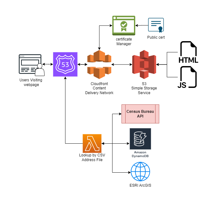
System Outline
This is an extension of the “AWS Area Eligibility API“ project that required a slightly modified architecture to
implement. It performs the same basic function that the eligibility API does but it allows users to upload a file to
the lambda function. This file is then processed, and a file is returned to the user with the results of the
processing. All of this is done without the use of S3 or signed URLs to minimize complexity and cost.
This uses the same static page as the Eligibility API with the small modification that DNS is now handled by AWS
Route 53 instead the original Google Domains. The difference is the removal of the AWS API Gateway and the
reconfiguration of all sub API Calls performed by the function.
The API call made to the Census bureau now uses its batch processing service where a CSV is supplied, and matching coordinates and geographies are returned. Input files can be of arbitrary size as the Lambda function will partition
them and recombine them after the API call.
The calls DynamoDB to also now operate in partitioned batched to stay under the 100 item/16mb query limits.
The API call to ESRIs public APIs for hosted feature layers is a new addition that is necessary for performing
point in polygon checks of rural designation.
All of these pieces get combined and a CSV file showing the results is returned to the user to complete the API
call.
Try it here: Summer Food Batch Processing